| |
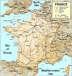
France is shaped like a hexagon, and three of its six sides are bounded by water — the English Channel on the northwest, the Atlantic Ocean and Bay of Biscay on the west, and the Mediterranean Sea on the southeast. The remaining sides are mostly mountainous and are shared by seven European neighbors — Belgium and Luxembourg on the northeast; Germany, Switzerland, and Italy on the east; and Spain and tiny Andorra on the south. France's eighth neighbor is Monaco, located on the Mediterranean coast near Nice and entirely surrounded by French territory. The diameter of the hexagon measures close to 1,000 km (620 mi) from each of its six corners to the opposite corner.
 |
|
|
| |
click on map to see large version (309k) |
|
| |
|
|
France may be divided into two regions by an imaginary line joining Biarritz in the southwest and Luxembourg in the northeast. Broad plains, low hills, and low plateaus predominate north and west of this line, and elevated plateaus and high mountains, including Mont Blanc, the highest point in Europe (except for the Caucasus Mountains), are found south and east of the line. Linking the two types of terrain, as well as providing easy communication with other parts of Europe, are several wide valleys and gaps, including the Belfort Gap, the Saone valley, the upper Rhône valley, the combined Rhône-Saone corridor south of Lyon, and the gaps at Carcassonne and Toulouse.
France is sometimes described as a microcosm of Europe because the three major types of European landforms — sedimentary basins and lowlands, worn-down Hercynian mountain blocks, and younger, folded mountain belts — are all well represented in France. The principal sedimentary basin is the Paris Basin, which forms a vast, saucer-shaped lowland, covering about 100,000 sq km (39,000 sq mi) and composed of alternating layers of hard and soft rocks that afford a varied relief. The smaller Aquitaine Basin, also sedimentary, lies southwest of the Paris Basin. Other lowlands include several long, narrow plains that run north-south, including the Alsace Plain west of the Rhine and the Rhône-Saone corridor, and coastal plains, including the Languedoc Plain, along the Mediterranean coast. The basins and plains have fertile soils, notably loam and alluvial deposits, and are excellent for farming.
The Hercynian mountain blocks are remnants of ancient mountains formed during the Hercynian orogeny (a mountain-building period during the Carboniferous and Permian periods, 340 to 230 million years ago) and subsequently worn down before being uplifted during the Tertiary Period (65 to 2 million years ago). The principal uplands are the Armorican Massif, the Massif Central, the Vosges, and the Ardennes. The Armorican Massif, located in northwestern France, is composed mainly of low plateaus. The Massif Central is located in south-central France between the Rhône-Saone corridor and the Aquitaine Basin, and consists of plateaus that rise to more than 1,000 m (3,300 ft); the Auvergne Mountains, of volcanic origin, rise from the plateaus of the Massif Central. The Vosges are located in eastern France between the Paris Basin and the Alsace Plain, and reach more than 1,200 m (4,000 ft) in the Ballons d'Alsace. A small portion of the Ardennes, which lie mostly in Belgium and Luxembourg, extends into France. The soils in all the Hercynian uplands are usually thin and developed on underlying granite and crystalline rocks.
The two principal mountain chains in France are the Pyrénées, which form the border with Spain, and the Alps, which form most of the border with Switzerland and Italy. The Pyrénées are difficult to cross because of their high altitude — several summits exceed 3,000 m (10,000 ft) — and the absence of low passes. The French Alps, the western end of the European Alpine chain, are also high and rugged, with elevations of 3,500 m (11,500 ft). Unlike the Pyrénées, however, the Alps are broken by several important river valleys, including the Rhône, Isère, and Durance, providing access to Switzerland and Italy. The Jura, a mountain range on the Swiss border, are lower and less rugged components of the Alpine chain.
France's coastline is 3,427 km (2,129 mi) long, including 644 km (400 mi) on Corsica. The character of the coastline ranges from sandy and straight, as in Languedoc on the Mediterranean, to deeply indented capes and bays, as in Brittany, the Côte d'Azur, and Corsica.
Daniel Noin; Reviewed by Anne Depigny and Agnes Jolivet.
Source: 2001 Grolier Multimedia Encyclopedia, ©2000 Grolier Interactive Inc. — All Rights Reserved.
Bibliography:
Image sources: Cover shot of "National Geographic Traveler: France" from Amazon.com Books. Topographic map of France, produced by the U.S. Central Intelligence Agency, from the Perry Castañeda Library Map Collection at the University of Texas.
| Land & Topography Links |
 |
|
|
Archives of the Ministry of Foreign Affairs
The Geographic division, first formed in January of 1775, is mainly responsible for research and for establishing maps for the Ministry. There are around 4000 maps in the collection, the oldest of which date back to the 17th century. Many of these archives may be consulted at the Quai d'Orsay reading room — 1, rue Robert Esnault Pelterie, 75007 Paris.
L'Association des Parcs et Jardins de France
Founded in 1983 by its current president, Bernard de Rochefoucauld, the Association of Parks and Gardens of France declares its mission: to open a greater number of parks, arboretums and private French gardens to the public.
Color Grid Maps of Paris
The City of Paris web site offers zoomable maps of every arrondissement, plus the two major wooded parks: Bois de Boulogne and Bois de Vincennes.
EdenPlanet.com
Le Figaro sponsors the French version of this horticultural site. By clicking on the link to "Fêtes des Plantes", one can view a listing of all the arboricultural festivals, floral celebrations and other related special events throughout France.
L'Europe Vue du Ciel
"Europe Seen from the Sky" maintains an online database of over 50,000 aerial images of regions, cities, and landmarks. Consultation requires user registration. (site in French, English & German)
Find a Garden
This massive database offers a handy search form, allowing one to locate gardens and parks throughout France (and several other countries). Search by name, style of garden, historical period when it was created, department or region. Results provide complete descriptions, location, visiting hours, photos, and more. (in French only)
Institut Géographique National
The IGN offers a wide selection of publications, topographical maps, and aerial photographs of France for sale — primarily for use in the education sector. (in French only)
Maps of France
The Perry Castañeda Library Map Collection provides an extensive array of topographical relief, historical and political (administrative) maps of France, as well as for many of its cities and overseas territories.
National Bureau of Forests
The ONF (Office National des Forêts) offers nature lovers a wonderful resource on exploring the public forests of France, with ample information on the flora and fauna of each.
Roman Roads and Land Organisation in Northwestern Gaul
A research unit at the University of Ghent has undertaken to reconstruct and interpret the Roman road system and land organisation, through the use of aerial photography, archaeological excavation, cartographic studies, and other methods.
Le Site Bois et Forêt
Marie Wilfried has assembled an exhaustive resource (in French only) about the woods and forests of France, including ancient maps, educational articles, poetry, photos, public forums, and much more.
Waterways of France
Providing essential transport for trade over the centuries, France's many rivers and canals have been a strategic economic resource. They also offer travelers a leisurely way to tour the countryside!
Zoomable Satellite Images
National Geographic's MapMachine™ provides an aerial view of the world, allowing one to compare the varying topography and vegetation of every region.
|
|
| National Parks |
|
|
|
Cévennes National Park
Designated a National Park in 1970, Cévennes is recognized by the World Biosphere Reserve as a model park, for its conservation of biodiversity and landscape. Approximately 2,250 species of flora may be found here, including 33 species protected by French law.
|
|
| Nominate A Site! |
|
|
|
|
|
|