| home | • | bookstore | • | boutique | • | contact us | • | news headlines | • | help! | • | share | • | site map | • | travel center |
 |
 |
 |
| |||||||||||||||||||
| |||||||||||||||||||

|
|
|||
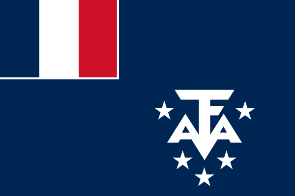
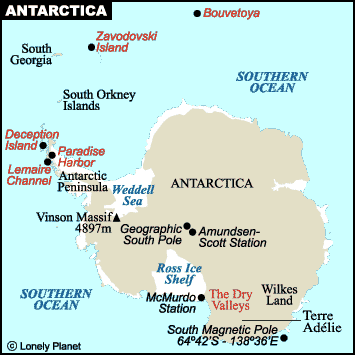
Official TAAF flag, The French Southern and Antarctic Territories — Terres Australes et Antarctiques Françaises (TAAF) — form an overseas territory of France, established in 1955, that consists of several groups of islands in the southern Indian Ocean and a sector of Antarctica (see maps) that is claimed by France. (Hereafter, both the territory and its governing body will be referred to simply as “TAAF”.) The Antarctic territory is called Adélie Coast (Terre Adélie). It includes the area between 136° and 143° east longitude south of the Antarctic Circle and is about 389,000 km² (150,200 mi²) in area. A staffed research station is located at Base Dumont d'Urville, with a smaller satellite base at Cap Prud'homme established to support supply runs to the inland Franco-Italian base Concordia on Dome C. TAAF's island components include the Kerguelen Archipelago, a group of one large and some 300 small islands, with a total area of about 7,000 km² (2,700 mi²); the Crozet Archipelago, consisting of 5 large and 15 tiny islands, with a combined area of about 300 km² (116 mi²); St. Paul Island, which is about 7 km² (2.7 mi²); and Amsterdam Island (Nouvelle-Amsterdam), with an area of 60 km² (23 mi²). All are rugged volcanic islands, uninhabited except for the various research stations: 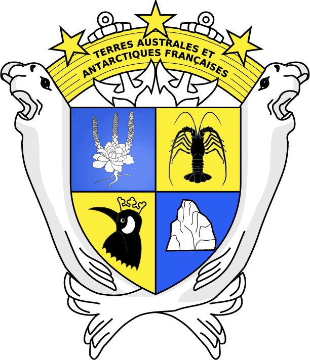
TAAF coat-of-arms, featuring
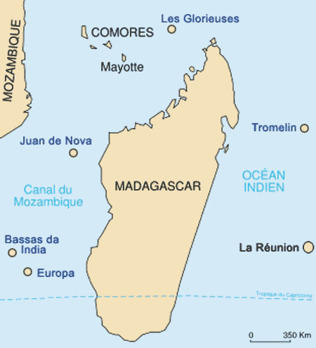
• Port-aux-Français station — 49°20'56.7"S, 70°13'08.8"E in the Kerguelen Islands The UNESCO World Heritage Convention describes the TAAF districts as an “oasis”, covering an area of over 166 million hectares (640,930 mi2), with “one of the highest concentrations of birds and marine mammals in the world.” In January 2005, the TAAF office also assumed the administration of several small tropical islands and an atoll in the waters surrounding Madagascar, known collectively as the Scattered Islands (fr. Îles Éparses): Bassas da India, Europa, Juan de Nova, Les Îles Glorieuses (Glorioso Islands), and Tromelin (see map). They were previously administered as dependencies of Madagascar, and then (after Madagascar became independent) as dependencies of Réunion. All of these islands are wildlife sanctuaries, closed to visitors except by special permit. Certain islands host small French military posts. Sovereignty over some or all of the islands is contested by the Comoros, Madagascar, and Mauritius. The TAAF administration is based in Saint-Pierre, Réunion, under the authority of a Prefect (presently Florence Jeanblanc-Risler, since 10/2022) who is appointed by the French government. TAAF is responsible for the operational management of its various bases — including construction, building maintenance, water, electricity, fuel, resupply, and related logistics. Most on-site logistical tasks are handled by French military personnel on annual rotations. A consultative committee with representatives from civil and military administrations, scientists, and the fishing industry advises the administrator. The Institut Polaire Français Paul-Émile Victor (IPEV) is charged with maintenance of the scientific laboratories, installation of new research facilities and equipment, supplies and upkeep, and renovation of remote shelters (fr. les cabanes) used for the different science programs. In coordination with TAAF, IPEV is involved in the recruiting, interviewing, and qualification process for hiring base scientists. Guidelines for the medical screening — physical and psychological — of TAAF and IPEV expedition personnel are stringent, in consideration of the districts' isolated nature and the challenges posed by medical evacuation (up to 10 days by ship, depending on the location). CNRS, the French National Center for Scientific Research (Centre National de la Recherche Scientifique) conducts extensive studies on a variety of disciplines, including marine and atmospheric conditions, glaciology, biodiversity, and climate change. CNRS conducts research on the geological history of Antarctica, including drilling into ice cores to reconstruct past climates and understand the evolution of the ice sheet. CNES, the French National Center for Space Studies (Centre National d'Études Spatiales) established under President Charles de Gaulle in 1961, maintains a prominent presence on Kerguelen Island, with a complex 4 km (2.5 mi.) east of the Port-aux-Français base where it has been tracking French and European satellites since 1985. There is another monitoring station on the Crozet Islands at the Alfred-Faure base on Île de la Possession. CNES also has a presence on Amsterdam Island, although its exact nature (satellite tracking station or other) is not specified in public search results. Commercial Exploitation (19th - 20th Centuries)Following the discoveries and its initial claims of subantarctic islands, France allowed long periods of time to elapse before revisiting or laying permanent claim to them, even abandoning prior claims (Amsterdam and St. Paul) at one point. Entrepreneurial sealers and whalers from other countries — notably the Americans from Nantucket, soon followed by the British and Norwegians — availed themselves of the sovereignty gap to exploit the live resources, even to the point of near-extinction of some pinniped species. Eventually, French kings and later governments of the Republic came to realize that there were potential profits to be made from these resources. Thus, commercial activities marked the early history of the French Southern and Antarctic Lands, leading to significant ecological consequences — some unintentional, others quite consciously undertaken. • Sealing and Whaling: In the 19th and early 20th centuries, sealers and whalers exploited the region's populations of pinnipeds and cetaceans. At its outset, it was quite a lucrative industry, owing to the demand for lamp oil; fur seal skins were also highly prized in China, where they were used for clothing trim, coats, and muffs. The Bossière brothers, Henry and René-Émile, subcontracted a whale oil processing facility to a Norwegian company, Aktieselskabet Kerguelen (A/S Kerguelen), at Port-Jeanne-d'Arc (PJDA, or Péjida in Taafien). It operated from 1908 to 1911 before being abandoned. Many traces of the old equipment remain; some of the buildings were restored by TAAF between 1977 and 2007, due to their historic nature. But the French weren't done with seal hunting after the Bossière brothers' venture. Marc Péchenart's company, SIDAP — Société Industrielle des Abattoirs Parisiens (en. Industrial Society of Parisian Slaughterhouses) — operated an elephant seal processing plant equipped with Australian machinery at Port-aux-Français from 1957 to 1960 before closing down. The disused equipment was finally sent to Réunion in 2005. • Fishing on a grand scale: The Patagonian toothfish (Dissostichus eleginoides), also known as Chilean sea bass, became a valuable commodity by the latter half of the 20th century. Illegal, unreported, and unregulated (IUU) fishing activities pose a significant threat to marine ecosystems. Fish populations have declined due to overfishing, and poachers from various countries are often hard to apprehend. • A number of other ventures were also attempted, with mixed and — in some cases — grievous results: breeding cattle on Amsterdam (1871), given up after only 7 months; raising sheep at Port-Couvreux (1912), tragically unsuccessful, as a forlorn graveyard of family members attests; salmon farming/hatchery at Lac d'Armor (1984-1991), moderately successful albeit short-lived after much trial-and-error. • In 1877, a French company attempted coal mining on Kerguelen Island, but the operation was soon abandoned due to the poor quality of the coal. • Philately (stamps are only issued for use in the TAAF) and fishing (with strict lobster and fish quotas) are the only recent “commercial” activities in the TAAF. The territory generates revenues of about €16 million (US$18.1 million) a year. Shift in Attitudes and UNESCO World Heritage StatusIn recent decades, France has shifted its approach to the TAAF, emphasizing conservation, scientific research, and sustainable resource management. • Environmental Protection: Recognizing the region's ecological significance, France declared the TAAF islands as a National Nature Reserve in 2006, expanding it to include the entire Exclusive Economic Zone (EEZ) in 2016. • Sustainable Fisheries Management: France has implemented strict regulations within its EEZ to combat IUU fishing and promote sustainable fishing practices. These measures include surveillance, patrol, and monitoring of fishing vessels. • UNESCO Recognition: The French Austral Lands and Seas were inscribed on UNESCO's World Heritage List in 2019, marking a significant milestone in recognizing their outstanding universal value. UNESCO designation acknowledges the site's unique biodiversity, ecological processes, and importance for scientific research. Toponymy of the TAAF Districtsto•pon•y•my (noun): the place-names of a region or language or especially the etymological study of them. Origin: late 19th century — from Greek topos place + onuma name. — Merriam-Webster Dictionary The naming of districts and geographical features within the TAAF region reflects a blend of French exploration history, maritime tradition, and scientific endeavor. Over the 250+ years since their discoveries, a number of sea captains, cartographers, and governmental organizations have been involved in assigning place-names for the bays, capes, cascades, fjords, mountains, valleys, and other physical locations throughout the TAAF. Due to its size — orders of magnitude larger than Crozet or Amsterdam Islands — and its vastly varied landscapes, it's no surprise that Kerguelen Island has been bestowed with the greatest number of place-names. On his discovery voyage (1772), and again on a second expedition (1773), Yves-Joseph de Kerguelen-Trémarec named many of the land's features visible from the water; ironically he himself never set foot on the island. (It was his first officer on the Gros Ventre, Charles du Boisguehenneuc, who did land with 20 crew and claimed the island for France.) The British explorer James Cook, on his third expedition in 1776, recognized France's claim to the island as “Kerguelen's Land” (while also calling it “Desolation Island”). He commissioned his lieutenant William Bligh (future captain of the HMS Bounty) to name about 20 locations — notably Christmas Harbor (Baie de l'Oiseau) where his ships Discovery and Resolution achored on 12/25/1776, and others named after various British luminaries and naval commanders.[4] The major cartographic works published since World War I were those of Raymond Rallier du Baty in 1922 and Edgar Aubert de La Rüe in 1932. Rallier du Baty (30 August 1881 – 7 May 1978) had made two expeditions to the Kerguelen Islands, in 1908/1909 and 1913/1914. He named roughly 200 places there after French navy officers, public figures, friends, family members, politicians, royalty, and even place-names from his native Brittany — such as Golfe du Morbihan (named Royal Sound by Cook); Morbihan means “the little sea” in Breton language. Aubert de La Rüe (7 Oct. 1901 – 24 Feb. 1991) was a French geographer, geologist, traveler, photographer, and a scientific adviser to TAAF. He visited the Kerguelen Islands to perform surveys in 1928, 1929, 1931, and from 1949 to 1953 — naming over 120 different places. The names he assigned include Baie Charrier, after the captain of l'Espérance; Mont Léon-Lutaud, after a professor of geography and geology at the Sorbonne; Anse de Saint-Malo, after the historic walled city in Brittany. On the Crozet Islands, a number of landmarks were named after vessels that had visited the district ( Antarès in 1931; Gauss in 1902; La Meurthe in 1887), or who had manned those vessels — among them Commander Frédéric Richard-Foy on La Meurthe, dispatched to save 13 shipwrecked mariners from Le Tamaris on Île des Cochons. Hydrologists, naturalists, and geological engineers (notably H. de Corbiac, 1966-1967) named some island features, often in a literal descriptive fashion — Aiguille (en. needle), Grand Roc, L'Obélisque, Pignon Rouge (en. red pinion). A TAAF commission also assigned a number of place-names to the archipelago between 1962 and 1971. During the late 1960s, the Commission Territoriale de Toponymie tapped Gracie Delépine[5] to compile a comprehensive list — along with the origins — of place-names encompassing the major TAAF islands. Madame Delépine's complex and delicate work, entitled Toponymie des Terres Australes (preface by Pierre Charles Rolland, Prefect of TAAF 1958-1972), was completed in July 1972 and released in Feb. 1973. It comprises no fewer than 1,576 records, including:
— 1,353 for the Kerguelen Islands; It coincided with a systematic mapping effort in the late 1960s and early 1970s by the Institut Géographique National (IGN). TAAF's toponymic traditions have continued in modern times, even applying to the naming of buildings on the bases, some of which commemorate people[6], while others honor Breton customs and language[7]. [4] Prince of Wales Peninsula, after the young Prince of Wales, George Augustus of Hanover (who later became King George IV). Île Howe, after Lord Howe, commander of the British armies in North America. Mont Campbell, after Vice-Admiral John Campbell. Pointe Pringle, after Sir John Pringle, president of the Royal Society (and a friend of Cook). [5] Gracie Delépine (born 12 February 1930) is a French historian and honorary chief curator of the Bibliothèque Nationale de France. She is mainly known for her work on the history of the Kerguelen Islands. [6] On Kerguelen, the residence which houses military personnel is named Louison, ironically commemorating Marie-Louise Séguin, the ˜14-year-old mistress of Yves-Joseph de Kerguelen-Trémarec — the 39-year-old captain after whom the island is named. She was smuggled on board Kerguelen's second expedition to the islands, disguised as a boy, and not listed on the ship's manifest — in effect a stowaway. That violation of French naval rules not only caused dissension among the crew, but also contributed to Kerguelen being court-martialed upon his return to Brittany. [7] One of the older residences at Port-aux-Français (PAF) on Kerguelen is named Keravel (or Ker-Avel), a Breton name which translates roughly to “House of Wind” — appropriate for a place where wind speeds average 110 km/hr (68 mph) year-round. The PAF refectory, also the base's nerve center and social hub, is named TiKer. In the Breton language, “Ty'Ker” means the village house or town hall. Exclusive Economic Zones (EEZs)France has established wide-ranging Exclusive Economic Zones (EEZs) around its TAAF territories, asserting sovereign rights over the living and non-living resources within these zones. The TAAF authority adopted a protection perimeter around the nature reserve in 2017, covering the total French EEZ — 990,000 km2 (382,000 mi.2). Governance and environmental regulations of a nature reserve apply to this perimeter. 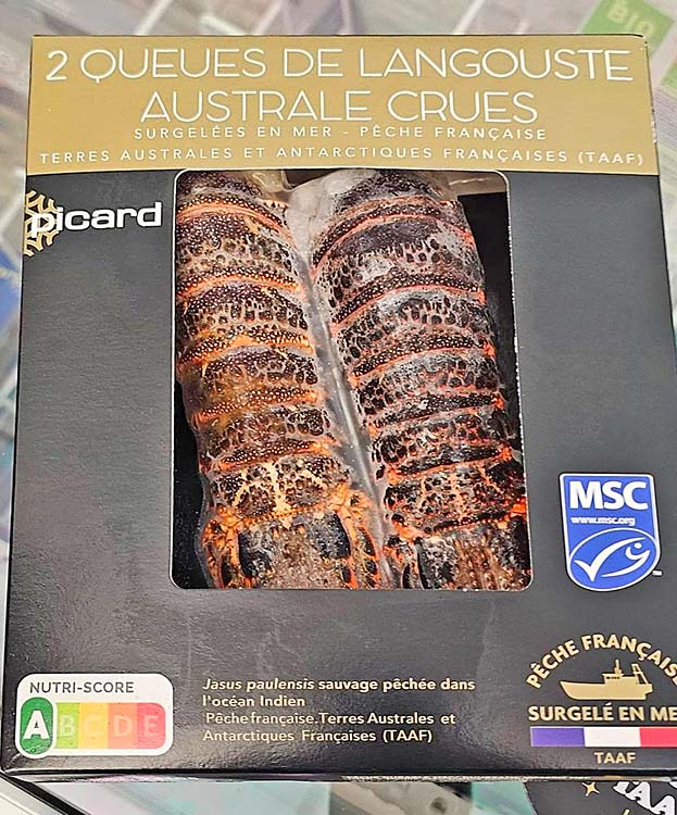
Lobster from the waters near St. Paul Island, packaged for sale in France. (click on image to enlarge) • EEZ Range: The EEZs extend 200 nautical miles (370 km) from the islands' coastlines. • Patrols: The French Navy[8] patrols these zones to enforce fisheries regulations, combat illegal fishing, and ensure maritime security. Surveillance is also carried out via satellite. A bilateral agreement with Australia uses satellite technology for joint surveillance and patrolling of the region. • Fisheries Management: Within the EEZs, France implements rigorous fisheries management measures, including strict quotas, licensing, and monitoring of fishing activities. These measures aim to ensure the sustainable exploitation of resources such as Patagonian toothfish and spiny lobster. • Limited Fishing Fleet: There are presently seven long-line[9] toothfish fishing boats operating in the EEZ. The toothfish fishery received Marine Stewardship Council (MSC) certification for Kerguelen in 2013 and Crozet in 2017. • Lobster: Just one lobster fishing boat, the Austral, operates in the area — primarily off Amsterdam and St. Paul Islands. It received MSC certification for sustainable fishing practices in 2020. When fire swept Amsterdam on 01/16/25, Austral was closest to the island and evacuated the 31 members of the base. • Vigilante Enforcement: While not sponsored or encouraged by French authorities, vigilante enforcement of the EEZ against poachers does happen. Case in point: the Bob Barker, flagged in the Netherlands, chased the notorious trawler Thunder for 10,000 miles, confiscating its nets along the way. (See full NYT story.) SummaryThe French Southern and Antarctic Lands have been transformed from a region of commercial exploitation to a protected area recognized for its ecological significance. The establishment of the TAAF governing body, a shift in French attitudes towards conservation, and the declaration of the region as a UNESCO World Heritage Site reflect a commitment to preserving this unique environment. France's ongoing efforts to manage fisheries sustainably and enforce its EEZs are vital for safeguarding the biodiversity and ecological integrity of the French Southern and Antarctic Lands. [8] When not engaged in ice-breaking and resupplying the Dumont d'Urville base on Antarctica, the Astrolabe also serves as a Navy patrol ship in the TAAF. Other Navy ships, some equipped with machine guns, include the B2M class Champlain and the Auguste Techer based out of Réunion.[8] [9] In recent years, long-line fishing has encountered new challenges that cut toothfish catches down drastically and jeopardize fishermen's livelihoods. It seems that sperm and killer whales have learned to slide the long-lines between their teeth, picking off the fish right down the line, a technique called depredation and nicknamed flossing. (See story.) Editing, translation, and portions written by Ian C. Mills © 2000- – All Rights Reserved. Sources:
Aubert de la Rüe, Edgar (1968). Remarques sur la toponymie des îles Kerguelen. TAAF n42-43: 12-41.
Delépine, Gracie (1995). Les îles australes françaises — Kerguelen, Crozet, Amsterdam, Saint-Paul.
Rennes: Édition Ouest-France.
Delépine, Gracie, Commission Territoriale de Toponymie (1973). Toponymie des Terres Australes. Paris: TAAF (éd. Documentation française). 433 pages (in French).
Fleury, Christian and Raoulx, Benoît (2015). Toponymy, Taxonomy and Place — Explicating the French concepts of presqu'île and péninsule. University of Caen, Normandy.
Fuligni, Bruno (2022). L'Argot des manchots: Petit lexique en usage dans les Terres australes et antarctiques françaises. Hémisphères éditions.
Hince, Bernadette (2008). Subantarctica: the Auckland Islands and Joan Druett's Island of the Lost. Shima, 2(1), 103-114.
Martin-Nielsen, Janet. A Few Acres of Ice — Environment, Sovereignty, and Grandeur in the French Antarctic. PDF download; 275 pages. Cornell University Press, Ithaca (NY) and London. © 2023 by Cornell University.
Pratt, Mary Louise (1992). Imperial Eyes: Travel Writing and Transculturation. Routledge, London/New York, p. 38.
Prince, Solène (2018). Science and culture in the Kerguelen Islands: a relational approach to the spatial formation of a subantarctic archipelago. Island Studies Journal, 13(2), 2018, 129-144.
European Tourism Research Institute (ETOUR); Department of Tourism Studies and Geography, Mid-Sweden University, Sweden.
Rallier du Baty, Raymond (1922). Le voyage de la Curieuse (1912-1914). Paris: La Géographie, vXXXVII n1: 1-26.
West-Sooby, John (2013), editor. Discovery and Empire; the French in the South Seas. Adelaide: The University of Adelaide Press, Australia. Images: 'Map of Antarctica' © Lonely Planet. 'Flag of the TAAF, officially adopted on 23 February 2007 by law #2007-18', from Wikimedia Commons. 'Lobster from the waters near St. Paul Island, packaged for sale in France', from Facebook; photographer: Robert Exposito, Chef d'Entreprise at Antic French Touch, Dieulefit, Rhone-Alpes, France. – All Rights Reserved.
|
||||||
|
||||||||||


