| home | • | bookstore | • | boutique | • | contact us | • | news headlines | • | help! | • | share | • | site map | • | travel center |
 |
 |
 |
| |||||||||||||||||||
| |||||||||||||||||||

|
|
|||
Geography and GeologyAmsterdam
Looking down at the caldera from the summit of Mont de la Dives on Amsterdam Island. © Cyril Szakolczaï - Photos des TAAF All Rights Reserved (click on image to see larger version) Amsterdam (37°52' S, 77°32 E) is a small volcanic island in the Indian Ocean about 1,860 miles (3,000 km) from any continent. Shaped like an ellipse oriented north-south (see map), Amsterdam is 5.7 miles (9.2 km) long, 4.6 miles (7.4 km) wide, with an area of about 21 square miles (55 km2) and a coastline 17 miles (28 km) long. The shoreline consists entirely of cliffs, except for "Pointe de la Recherche" (Research Point) at the north and "Mare aux Elephants" (Elephant seal pond) at the northwest, close to the scientific base. The western high cliffs (1,310 feet/400m to over 2,300 feet/700m high) have been caused by a geological collapse and give the island a dissymmetrical shape. Facing southwest, Entrecasteaux Head is the only jutting headland of the isle. The highest peak, at 2,890 feet (881m) high, is "Mont de la Dives". Amsterdam Island, which is wholly of volcanic origin, rises 31 miles (50 km) south of the Mid-Indian Ridge. It used to be a rather ordinary volcano made up of lava-overflows and projected basaltic scoria. The island emerged in two stages during the last 690,000 years, and probably most extensively over a span of 400,000 to 200,000 years ago.
The first stage gave birth to a 17-square-mile (44 km2) large paleo-volcano whose only remains nowadays cover 5% of the isle (1.2 mi2/3 km2) with "Le Fernand" 2,400 feet (731m), "Le Grand Balcon" (the upper balcony - 2,020 feet/616m), "La Grande Marmite" (the big pot-hole - 2,400 feet/730m), and "Le Pignon" (the gable - 2,360 feet/720m). The second stage produced the neovolcano "La Dives" and its lava-flows out of the caldera. Some of these may be several kilometres long, the largest of all being the 1,900-foot-wide (600m) "Plateau des Tourbières" (peat-bog plateau); some others created lava-tunnels too. Scoria-cones appeared at the end of the volcanic activity; the most recent among them dates back to the previous century. These include Cratère Antonelli (with Cabane Antonelli perched on its rim), le Brûlot, le Chaudron, le Cyclope, Cratères Dumas, le Fourneau, Cratère Hébert, le Museau de Tanche, Cratère de l'Olympe, Cratères Vénus (Inférieur & Supérieur), and Cratère Vulcain. No sign of volcanic activity has been recorded recently on the island. A detailed interactive topographic map of the island was created in 1967 by l'Institut Géographique National – Call Number MAP G9182.A5 1967 (Copy 2). Because of the map's age, the island's scientific base is still shown as La Roche Godon (later renamed to Martin-de-Viviès). Saint-PaulSaint-Paul (38°43' S, 77°29' E) is a small volcanic island in the Indian Ocean about 1,860 miles (3,000 km) from any continent, on the same meridian as Amsterdam Island 50 miles (80 km) to its north. Oblong in shape, oriented northwest to southeast from Pointe Smith to Pointe Hutchison (see map), Saint-Paul is approximately 3.2 miles long and 1.8 miles wide (from Pointe Ouest to the reef inlet of the crater lake), with a land area of about 3.2 square miles (8.4 km2), and a maximum altitude of 892 feet (272m). Glossary of Terms
Climate
The swan song of an elephant seal. © Jean-Luc Bourrian All Rights Reserved (click on image to see larger version) Amsterdam Island enjoys a temperate ocean-like climate. The average annual air temperature is 56.8°F/13.8°C, with a limited range extending from 52.2°F/11.2°C in August (winter) to 62.6°F/17.0°C in February (summer). The most extreme temperatures ever recorded under cover at sea-level were 35.2°F/+1.8°C (July 1964) and 78.4°F/25.8°C (January 1989). Annual rainfall averages 44.1 inches (1,121mm), mainly consisting of drizzle. There are an average of 238 rainy days a year, winter being moister than summer. Howevever, the heaviest rainfalls within a 24-hour period are recorded in summer — when extratropical depressions and cyclone-tails sweep across the isle. The air humidity averages 80% year-round, without any seasonal variations. Northwesterly winds prevail and match the northern-most strong gales of the Roaring Forties(1). The average windspeed in a year at sea-level is 7.4 metres per second (m/s) (17 mph or 27 km/h). Violent gales of over 16 m/s (58 mph or 93 km/h) have usually been registered for 163 days a year with a peak of 56 m/s (125 mph or 202 km/h) in June 1950. The most violent winds ever registered on the base reached 87 mph (140 km/h) during the extratropical storm "Anacelle" on February 14th 1998. (1) Roaring Forties:
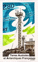
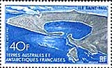
Editor: Ian C. Mills. © 2003-. All Rights Reserved. Images: 'Maps of Ile Amsterdam and Ile St-Paul', from the Perry-Castañeda Library Map Collection at The University of Texas in Austin. 'Looking down at the caldera from the summit of Mont de la Dives on Amsterdam Island', from Photos des TAAF, a web site produced by Cyril Szakolczaï. 'A 2,8-franc TAAF postage stamp depicting weather station on Amsterdam Island (Station de Pointe Bénédicte)', from Philatélie des Terres Australes et Antarctiques Françaises, a web site maintained by Loïc Guérin. 'A 40-franc TAAF postage stamp, depicting Saint-Paul Island', from Albany Stamp Co. 'The swan song of an elephant seal', from L'Album Photos de l'Ile Amsterdam, a web site published by Jean-Luc Bourrian. All Rights Reserved. Next page >> Flora and Fauna |
||||||||||||||||||||||||||||||||||||||||||||||||||||||||||||||||||||||||||||||||||||||||||||||||||||||||||||||||||||||||||||||||||||||||||||||||||||||||||||||||||||||||||||||||||||||||||||||||||
|
||||||||||


