| |
| | |
| |
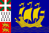
The French tricolore is the official flag of Saint-Pierre and Miquelon. The territorial coat-of-arms — which may be flown underneath the flag of France — depicts the ship on which the islands' settlers arrived, along with the symbols of their Basque, Breton and Norman heritage.
 |
|
| |
Saint-Pierre and Miquelon {mik-uh-lawn'} is an archipelago — a group of 8 small islands (see map) in the North Atlantic Ocean about 10 miles (16 km) southwest of Newfoundland's Burin Peninsula. Miquelon is about 3 miles (5 km) northwest of Saint-Pierre and 15 miles (25 km) west of the peninsula.
Miquelon is actually two islands which are joined by a slender, 10-mile (16-km) long sandbar isthmus. Grande Miquelon is to the north; Langlade, or Petite Miquelon, is south of the isthmus. There are several islets off the northern and eastern coasts of Saint-Pierre and just northeast of Miquelon. Four of these also have names: Le Grand Colombier, l'Ile aux Pigeons (Pigeon's Island), l'Ile aux Vainqueurs (Victor's Island), and l'Ile aux Marins (Sailor's Island). All the islands are rocky, with little vegetation, and have a cold, foggy climate.
The total area of the two main islands is 93 square miles (242 sq km). Most of the territory's population of 6,928 (July 2001 est.) live on Saint-Pierre's 10 square miles (26 sq km) in its capital and commercial center — the town of Saint-Pierre on the island's east coast, although Miquelon's 83 square miles (215 sq km) are also inhabited.
Most of the forest cover of the islands has been cut for fuel, and only low shrub growth remains. The chief industries are fishing and the processing of fish — salting, drying, canning, and freezing codfish. The islands' entire economy depends on the nearby Grand Banks fisheries, although there was a depletion of stock in the 1990s. Saint-Pierre's harbor is kept virtually ice-free by the passing Gulf Stream. There are some minor enterprises, such as mink and silver-fox farming, whose animals are raised on fish. Nearly all consumer goods must be imported. French financial aid is indispensable.
| | |
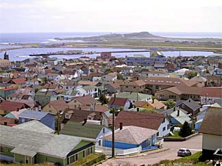
View of Saint-Pierre
Photograph by Christophe Marciniak |
|
| |
The population of the islands is of French origin and speaks French. The territory has compulsory primary education, provided mainly by Roman Catholic schools, and a small secondary and vocational educational system. Most of the population is literate.
HISTORY
The Territory of Saint-Pierre and Miquelon Islands is all that remains of the old French colonial empire in northern North America. Breton, Basque, and Norman fishermen were fishing off the islands early in the 16th century, and in 1535 Jacques Cartier claimed the islands for France. The present population is descended largely from French Canadians who were expelled by the British from Newfoundland and Acadia in the 18th century.
Originally discovered by the Portuguese early in the 1500s, the islands were several times occupied by the British, but have been in continuous French possession since 1816. They had the status of a colony until Jan. 1, 1947, when they became a partially autonomous overseas territory of France with representation in the French Parliament and French Union.
The islands voted in 1958 to retain their status as a territory of France, but the French government decided to make them a department of France, and this change was given final approval by the French Senate on July 9, 1976. The islands send a deputy and a senator to the French Parliament. Since 1985, the department has reverted to the status of territoire d'outre-mer, a territorial collectivity.
Source: 2001 Grolier Multimedia Encyclopedia, ©2000 Grolier Interactive Inc. ; and The Encyclopedia Americana, a division of Grolier Online — All Rights Reserved.
Images: Territorial coat-of-arms for St-Pierre and Miquelon, from Flags of the World web site. View of Saint-Pierre, from Photos of Saint-Pierre and Miquelon web site, © Christophe and Laleña Marciniak — All Rights Reserved.
 Saint-Pierre and Miquelon Links Saint-Pierre and Miquelon Links |
|
Welcome to Saint-Pierre and Miquelon
It might surprise you to know that such a remote and tiny territory sports quite an extensive web presence. Hosted by Marc Cormier since 1994, the site offers in-depth coverage of the territory's history over the centuries, plus background on the languages and cultures of its Acadian, Basque, Breton, and Normand residents, as well as photographic galleries, samples of stamps and old currency.
Photos of Saint-Pierre and Miquelon
Assembled and hosted by Christophe and Laleña Marciniak, this collection spans over 1,000 views of a very picturesque and rugged land.
CIA World Factbook: Saint-Pierre and Miquelon
Extensive statistics on the region's geography, people, government, economy, communications infrastructure, transportation, and military.
Current Time: Saint-Pierre, Saint-Pierre and Miquelon
Is this a good time to call someone in Saint-Pierre and Miquelon? Find out by checking the correct local time in the capital.
Color Map of Saint-Pierre and Miquelon
This highly detailed atlas map — suitable for printing — is in PDF format (268k file size) and requires Acrobat™ Reader, free from Adobe.
1763 Map of Saint-Pierre and Miquelon
Archived in the Research Collection of the McMaster University Library (Hamilton, Ontario), this rare map was drawn in 1763 by Jacques Nicolas Bellin for France's war and maritime ministry. The following year, Bellin published another map of just Saint-Pierre, which shows details of coast shoals, rocks, soundings, vegetation, and relief (oriented with north to the right).
|
| Recommended Books & Films |
|
 The Widow of Saint-Pierre
Starring: Juliette Binoche, Daniel Auteuil, Emir Kusturica. Director: Patrice Leconte.
While a guillotine and an executioner are sent from France, a convict sentenced to death on the isolated island of Saint-Pierre strives to better himself in the eyes of the police chief's beautiful wife. (French w/ English subtitles, plus dubbed English soundtrack)
|
| Nominate A Site — Submit An Article! |
|
French Colonies, Overseas Territories
Do you know about a great site we should list here? It can be devoted to any aspect of historical French colonization (people, places, events), or contemporary locations still administered by France – collectively known as DOM-TOM (for départements/territoires d'outre-mer). Please use our convenient Submission Form to send your suggestions!
Are you an author, educator, student or traveler who would like to write an article for the enjoyment of our francophile community? Please download our author's guidelines (48K PDF). Thank you!
|
|
|