| home | • | bookstore | • | boutique | • | contact us | • | news headlines | • | help! | • | share | • | site map | • | travel center |
 |
 |
 |
| |||||||||||||||||||
| |||||||||||||||||||
|
|
|||
|
Benin • Burkina Faso • Côte d'Ivoire • Guinea Mali • Mauritania • Niger • Senegal The Republic of Niger {ny'-jur} is a landlocked state on the southern edge of the Sahara in West Africa (see map). Niger is bounded by Algeria on the northwest, Libya on the northeast, Chad on the east, Nigeria and Benin on the south, and Burkina Faso (formerly Upper Volta) and Mali on the west. Niamey, located on the Niger River, is the national capital.
LAND AND RESOURCESThe topography of Niger consists of highlands and plains. The Aïr Massif (highest point: 1,073 m/3,520 ft), an extension of the Ahaggar (Hoggar) Mountains in Algeria, thrusts into central Niger (see Aïr and Ténéré Natural Reserves). In the northeast the Djado, Mangueni, and Tchigaï plateaus join the Aïr with the Tibesti Massif of northwestern Chad. The sandy, rocky plains of the Sahara extend to the east and west. To the south in the Sahel, a chain of arid plateaus — the Djerma Ganda, Adar Doutchi, and Tegama — parallels the southern frontier. The major stream is the Niger River, which extends for 480 km (300 mi) in the southwest (see also W National Park). Part of Lake Chad is in Niger's southeastern corner. The climate is tropical, and the year is divided into a short rainy season (June to October) and a dry period (November to May). Although the range of temperatures is greatest in the northeast, most parts of the country experience highs of about 40° C (104° F) in the hot season (February to May) and lows between 12° and 15° C (54° and 59° F) during the coldest months (December and January). Precipitation varies according to latitude: the northern desert receives almost no rain, whereas enough rain falls in the area south of Gouré (400 mm/16 in) and Tahoua to support herding; in the south, rainfall is adequate (560 mm/22 in) for settled agriculture. In the northern Sahara region some vegetation is found only after the rare rainfall. Farther west along the Niger and south in the Sahel open savanna predominates with scattered acacia, palm, and baobab trees. National tree planting is a regular feature in Niger in an effort to halt the advance of the desert, which now covers about two-thirds of the country. An estimated 7 million trees were planted in 1998 for this purpose. Fauna includes antelope, panther, lions, giraffes, leopards, and hyenas; crocodiles and hippopotamuses are found at the Niger River. In an effort to preserve its dwindling wildlife population, the government banned hunting in 2001. Niger possesses important mineral resources. The most valuable is uranium, and reserves in the northwestern Arlit region are among the largest in the world. Some gold, cassiterite, gypsum, phosphate, salt, iron, tin, tungsten, petroleum, and coal reserves also exist.
PEOPLEThe peoples of Niger fall into five groups classified by language and livelihood. The arid north and center of the country are home to the Tuareg camel and goat herders. Constituting 8% of the population, they speak Tamashek, a language related to Berber. Other pastoralists include the Fulani (8.5%), a cattle-keeping group whose West Atlantic language indicates that their forebears came from Senegal. In the east and northeast live the Teda and Daza (1%), small groups of herder-gatherers who speak Saharan languages. Related by language but not livelihood are the Kanuri (4.3%), agriculturists of the southeast, many of whom are now urban dwellers. But by far the most numerous ethnic group is the Hausa (56%), settled agriculturists who live in the south between Zinder and Dogondoutchi. Second to them are the Songhai-Djerma (22%), cultivators whose homeland is located west of Hausa territory. The vast majority of the people (nearly 90%) are Muslims; most others follow traditional religions. Each ethnic group speaks its own language; Hausa language is the major lingua franca, especially for trade. French remains the official language, although it is spoken by only a small minority. Great variations in population density exist: the lowest densities are found in the desert regions, especially in the northeast, and the highest are found along the Niger River. Niamey, the capital and largest city, is located in the south, as are the other large cities of Zinder, Maradi, and Tahoua. Educational and medical facilities are limited outside the larger cities. Although education is free and compulsory for all children from age 6 to age 15, only about 29% actually attend school. The University of Niamey was founded in 1971, and the Islamic University of West Africa at Say was inaugurated in 1987. ECONOMIC ACTIVITYThe economy rests on subsistence agriculture, animal husbandry, and exploitation of Niger's mineral wealth. Although only about 3% of the land is cultivated with crops, about 90% of the labor force are engaged in agriculture. Millet, sorghum, and rice are the major subsistence crops. Production of peanuts, formerly the most important agricultural export, has declined. During the mid-1970s cotton cultivation was introduced in order to reduce dependence on a single agricultural export. The nomadic peoples in north and central Niger practice animal husbandry, but their livelihood was adversely affected by drought in 1968-74, in 1984-85, and again in the 1990s and by the closing of the border with Nigeria from 1984 to 1986. Extraction of minerals (most notably uranium) for export is the leading industry. Mining was originally controlled by French interests, but German, U.S., and Japanese participation has increased. Manufacturing is limited to primary products — peanut oil and other processed foods, beer, cotton textiles, and cement. Niger has a large foreign debt and is heavily dependent on foreign aid, which was reduced after a 1996 coup. France's 1994 devaluation of Niger's currency, the C.F.A. franc, had the effect of greatly increasing Niger's exports to neighboring Nigeria. HISTORY AND GOVERNMENTFossils and artifacts in Niger testify to a long period of human habitation, and both Roman and later Arab historians described contact and trade with the region. During the Middle Ages the western part of present-day Niger formed part of the Songhai empire, established during the 7th century by Berbers, and had accepted Islam by the 11th century. Much of eastern Niger belonged to the state of Kanem-Bornu (14th-19th century). In the south city-states arose (c.14th century) among the Hausa and became southern termini for trans-Saharan commerce. During the early 19th century the Hausa states were conquered by Fulani under the Muslim reformer Usman dan Fodio. In the 1890s the French signed treaties with the rulers of the Say, Gaya, and Dosso states, but Niger did not become a formal French colony within French West Africa until 1922. In 1960 the colony gained its independence, and Hamani Diori, who had led the independence movement, became the first president. Diori governed until 1974, when a group of army officers accused him of mismanaging relief efforts during the devastating Sahelian drought of 1968-74. A military and civilian council, headed first by Col. Seyni Kountché (until his death in 1987) and later by Col. Ali Seybou, then ruled the country. In 1989 the first national elections since 1960 were held. Seybou, running unopposed, was elected to a 7-year term as president under a new constitution establishing a second republic. Rising demands for political reform led to the convening of a national conference in 1991 that stripped President Seybou of his powers. After a new multiparty constitution was adopted in December 1992, the former ruling party lost the 1993 presidential election. The opposition also won legislative elections in 1993 and 1995, leading to a political crisis. President Mahamane Ousmane was ousted in a coup on Jan. 27, 1996, and placed under house arrest. The constitution was suspended, political parties were banned, and coup leader Ibrahim Barré Maïnassara declared himself the new head of state. The ruling junta appointed a civilian prime minister who formed a civilian government, but Ibrahim halted the July 1996 elections after two days of chaotic voting, banned public meetings, and appointed a new electoral commission that declared him president. Maïnassara's "victory" was denounced by the opposition as an electoral "coup d'état." Legislative elections held in late 1996 were boycotted by the opposition. In December the president dissolved the National Salvation Council, which had ruled the country since the coup. The chaotic political situation was further destabilized by mutinies by unpaid soldiers, strikes by civil servants and employees of state corporations, and a continuing rebellion by the Tuareg minority in the north. The government signed peace accords with the Tuareg rebels and another rebel group in eastern Niger in November 1997; the Tuareg group was disarmed in June 1998. In late July the government reached an agreement with opposition parties that would allow all parties to participate on an equal footing in local elections held in February 1999, but the results of these elections were subsequently disputed by the opposition. On Apr. 9, 1999, as political instability continued, President Maïnassara was assassinated by members of his own security guard. The legislature and Supreme Court were dissolved, the constitution was suspended, and Maj. Daouda Mallam Wanke, the commander of the presidential guard, was named president and head of the new National Council for Reconciliation, which was to rule Niger for a nine-month transitional period. Army chief of staff Col. Moussa Moumouni Djermakoye (who had reportedly refused to accept the presidency unless Maïnassara's assassins were brought to justice) and other senior military and police officers were forced to retire. In June the military government increased the powers of the civilian prime minister. A July referendum on a new constitution that would divide power between a president and a prime minister won approval, although voter turnout was very low. The new constitution became effective in August 1999. The first round of presidential elections from which Wanke and other military personnel and members of the transitional government were barred were held in October 1999. Because none of the seven candidates won a majority, a runoff election was scheduled for November. Legislative elections were held at the same time as the final round of the presidential poll, which was won by retired army colonel Tandja Mamadou. Tandja's National Movement for the Development Society also won a majority of seats in the legislature. Wanke turned over power to the elected civilian government headed by Tandja on Dec. 22, 1999. In January 2000, Tandja appointed Hama Amadou, who had held that same post under Ousmane, as premier. In December the legislature granted the government the power to act on economic and financial matters by edict in order to put reforms demanded by international lenders and aid organizations into effect. In April 2002, Niger became the first Muslim nation to formally sever diplomatic relations with Israel since the latest round of Israeli-Palestinian violence began in the fall of 2000.
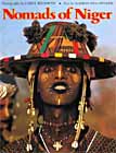
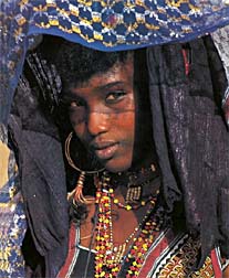
Dennis D. Cordell, Assistant Professor of History, Southern Methodist University, Dallas, Tex. Source: 2001 Grolier Multimedia Encyclopedia, ©2000 Grolier Interactive Inc. — All Rights Reserved. Bibliography: J. F. Ade Ajayi and M. Crowder, eds., The History of West Africa, 2 vols. (1971-74); B. Buerkert, et al., eds., Wind Erosion in Niger (1996); Robert B. Charlick, Niger (1991); R. O. Collins, African History in Documents: Western African History, vol. 1 (1990); Samuel Delcalo, Historical Dictionary of Niger, 3d ed. (1997); Philip Koslow, Centuries of Greatness: The West African Kingdoms 750-1900 (1994); L. Lamarque, Niger: Profiles of Agricultural Potential (1993); Christian Lund, Law, Power and Politics in Niger: Land Struggles and the Rural Code (1998); Patrick Manning, Francophone Sub-Saharan Africa (1988); Marion Van Offelen and Carol Beckwith (Photographer), Nomads of Niger (1983). Images: Map of Niger © Lonely Planet — All Rights Reserved. Nomadic woman of Niger © Carol Beckwith (Photographer), from book Nomads of Niger — All Rights Reserved. Benin • Burkina Faso • Côte d'Ivoire • Guinea Mali • Mauritania • Niger • Senegal
|
|||||||||||||||||||||||||||||||||||||||||||||

|
||||||||||