| home | • | bookstore | • | boutique | • | contact us | • | news headlines | • | help! | • | share | • | site map | • | travel center |
 |
 |
 |
| |||||||||||||||||||
| |||||||||||||||||||
|
|
|||
|
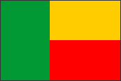
Benin • Burkina Faso • Côte d'Ivoire • Guinea Mali • Mauritania • Niger • Senegal Benin {be-neen'} is a small republic in West Africa known from 1960 to 1975 as the Republic of Dahomey (see map). Located on the Bight of Benin in the Gulf of Guinea, it is bordered on the east by Nigeria, on the north by Niger and Burkina Faso, and on the west by Togo.
LAND AND RESOURCESThe southern coastline extends only 120 km (75 mi) from east to west and comprises sandy beaches backed by lagoons and swamps. Benin has no natural harbors; Cotonou is an artificial port made accessible to ships by two artificial jetties built out into the shallow coastal waters. Inland from the coastal zone, forming most of central and southern Benin, is a generally flat lowland area with some low hills and marshlands. In the northeast is a plateau region of savanna grasslands, and in the northwest are the Atakora Mountains, the highest peaks in the country, which rise to 641 m (2,102 ft). The principal river is the Niger River, which forms part of the northeastern border (see also W National Park). The northern half of the nation drains toward the Niger River, the southern half directly into the Bight of Benin. The climate in the south is hot and humid throughout the year; the average monthly temperature is around 27° C (80° F), and rainfall on the coast totals 1,300 mm (50 in) a year. The northern sections have a tropical wet-and-dry (savanna) type of climate. Temperatures here are high throughout the year, but the summer months (June-October) are usually wet and humid and the winter months relatively dry and with lower humidity. The vegetation reflects the differences in rainfall regimes and grades from a tropical rain forest over most of the south to savanna grasslands toward the north. PEOPLEThe largest ethnic group are the Fon, or Dahomeyans, who constitute about 40% of the total population and predominate in the south. Other ethnic groups in the south include the Adja and Ewe, who are closely related to the Fon; the Yoruba; and the Aïzo, who are concentrated around Cotonou. In the north the principal ethnic groups are the Bariba in the northwest; the Somba in the northeast; and the Fulani, who have traditionally been nomadic herders. French is the official language. Fon and Yoruba are widely spoken in the south, and Bariba and Fulani are the principal languages in the north (see African languages).
Benin's population is unevenly distributed. More than two-thirds of the people live in the south, where population densities are among the highest in West Africa. The northern half of the country is only sparsely settled. Medical facilities are limited, and life expectancy is low. Nearly two-thirds of the population follow traditional (animist) religious beliefs; the remainder are Christians (mostly Roman Catholics) and Muslims. The school system is under government control and is free and compulsory. The only university is the National University of Benin. ECONOMIC ACTIVITYBenin is one of the poorest countries in West Africa. The economy is largely agricultural, and much of the labor force is engaged in subsistence farming. Palm kernels, grown mainly in the south, was long the principal cash crop, but cotton, grown mainly in the north, is now more important economically. Other cash crops include cocoa and coffee, grown mainly in the south. Millet and sorghum are the principal food crops in the north, and yams, cassava, corn, and peanuts in the south. The major manufacturing activities are mostly agriculture related and include cotton-ginning and oil-palm and sugar processing. Limestone and small amounts of gold and petroleum are extracted. The transportation system is poorly developed and comprises two short rail lines extending inland behind Cotonou and one extending inland as far as Parakou. A coastal highway links Benin with neighboring Nigeria and Togo. Benin sustains huge annual trade deficits that are relieved by infusions of monetary aid, especially from France. Since 1990, political and free-market economic reforms have stimulated private investment and led to economic growth, and the country has become a center for regional trade. GOVERNMENTAccording to a new constitution approved by voters in December 1990, Benin has a multiparty, presidential system of government. Both the president and members of the legislature, the National Assembly, are directly elected by universal suffrage, and a president may serve only two five-year terms. HISTORYThe kingdom of Dahomey, with its capital at Abomey, was preeminent in the region now known as Benin from the 17th to the early 19th century. It derived great wealth from trading slaves with Europeans along the coast, which was known as the Slave Coast. The French established a commercial agreement with the kingdom in 1851 and gradually consolidated their control of Dahomey until, in 1904, it was made a colony within French West Africa. The independent nation of Dahomey was established on Aug. 1, 1960. For the first 12 years of independence it experienced great political instability, partly because of the ethnic diversity of its population. Periods of civilian and military rule alternated, and the political scene was dominated by three figures — Hubert Maga, Justin Ahomadegbé, and Sourou Apithy, each of whom represented a different part of the country. Such violence erupted during the 1970 elections, especially between north and south, that the three agreed to form a presidential council, with each serving two years in a rotating presidency. The council was overthrown in 1972 in a military coup led by Mathieu Kerekou, who formed the Military Council of the Revolution (CNR) to govern the country and adopted Marxism-Leninism as the national ideology. The "colonial" name of Dahomey was abandoned in 1975, when the country was renamed Benin, and much of the economy was placed under government control. In 1979, under a new constitution (adopted 1977), the CNR was dissolved and legislative elections were held. An economic crisis and popular protests led to the abandonment of Marxism-Leninism as the official ideology in December 1989. Kerekou remained president of a transitional government created in 1990. In March 1991 elections under a new constitution he was the first incumbent African president to be ousted in democratic elections, and the country became known as a model of democratic reform in Africa. In March 1995 opponents of president Nicéphore Soglo won a majority of legislative seats. A year later Kerekou returned to power, having defeated Soglo in the runoff of the presidential election. In the legislative elections of April 1999, however, Soglo's supporters won a narrow majority in the National Assembly. Neither Kerekou nor Soglo captured an outright majority in the March 2001 presidential elections, forcing a second round of balloting. The runoff election was won by Kerekou, Soglo and the second-ranking opposition candidate having refused to participate in protest against alleged irregularities in the first round.
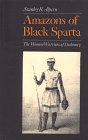
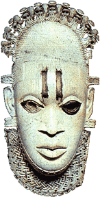
Reviewed by Godfrey Uzoigwe, Professor and Head of Department of History, University of Calabar, Calabar, Nigeria.�� Source: 2001 Grolier Multimedia Encyclopedia, ©2000 Grolier Interactive Inc. — All Rights Reserved. Bibliography: Chris Allen and Michael Radu, Benin and the Congo (1992); Samuel Decalo, Historical Dictionary of Benin , 3d ed. (1995); Stanley Diamond, Dahomey: Transition and Conflict in State Formation (1983); Patrick Manning, Slavery, Colonialism, and Economic Growth in Dahomey, 1640-1960 (1982). Images: Map of Benin © Lonely Planet — All Rights Reserved. 16th century Benin ivory pendant from The Art History Imagebase, maintained by Peter Hales at the University of Illinois, Chicago. Benin • Burkina Faso • Côte d'Ivoire • Guinea Mali • Mauritania • Niger • Senegal
|
|||||||||||||||||||||||||||||||||||||||||||||||

|
||||||||||